 |
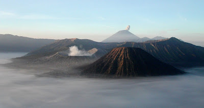
| Bromo Mountains |
Indonesia has more than one hundreds active dormant volcanoes shaped by tectonic activities. Indonesia is part of Pacific 'ring of fire'. They are formed due to subduction zones of three main active tectonic plates namely the Eurasian Plate, Pacific Plate, and Indo-Australian Plate.
There some volcanoes which are notable for their eruptions, for example: Krakatoa or Krakatau for its global effects in 1883, Lake Toba for its supervolcanic eruption estimated to have occurred 74,000 BP, which was responsible for six years of volcanic winter, and Mount Tambora, for the most violent eruption in recorded history in 1815. The eruption of Mount Tambora caused widespread harvest failures in Northern Europe, the Northeastern United States, and eastern Canada in 1816, which was known as the Year Without a Summer.
The most active volcanoes are Kelud and Mount Merapi on Java island, which have been responsible for thousands of deaths in the region. Since AD 1000, Kelud has erupted more than 30 times, of which the largest eruption was at scale 5 on the Volcanic Explosivity Index, while Merapi has erupted more than 80 times.
Where to climb
1. Merapi Mt (Central Java - 2,968 meters / 9,738 ft)
2. Merbabu Mt (Central Java - 3,145 meters / 10,318 ft)
3. Lawu Mount (Central Java - 3,265 meters / 10,712 ft)
4. Kelud Mt (East Java - 1,731 meters / 5,679 ft)
5. Bromo (East Java - 2,329 meters / 7,641 ft)
6. Ijen Mt (East Java - 2,799 meters / 9,183 ft)
5. Krakatoa / Krakatau (Sunda strait - 813 meters / 2,667 ft)
6. many more......

No comments:
Write comments